
An Dùn Beag

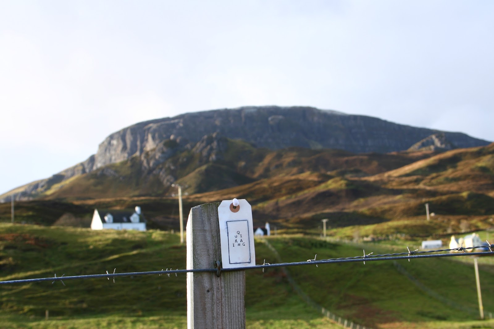
word-mntn (Quiraing); poem AF, photograph LA
begin with these stones
as the world began
(Hugh MacDiarmid)
begin with these names
as the poets began
(Davy Polmadie)

poem AF, photograph EN
we begin again with the Cuith-raing,
emblem of strength & ruin; it takes a slip of time
to climb the tussocky terraced incline
from sharp rush to soft mosses
the volcanic castellations of An Dùn Beag & Dùn Mòr
make a fort of the massive escarpment:
it takes a lavic mode of growth
& tertiary flows to set the needles slipping
down from Meall na Suiramach
to the sea
An Dùn Beag (Grid ref: NG4668), The Little Fort, with Dùn Mòr, The Big Fort, nearby, as at
Ullinish, in the guide to another fort named Dùn Beag with a Big Fort a short walk away; for
An Dùn Beag site records see RCAHMS. The Quiraing, or Cuith-raing, Round Fold, the name
is said to derive from its use as a shelter, concealing cattle from Viking raiders. Poucher trans-
lates Meall na Suiramach, the hill above the Quiraing, as Height of the Maiden. The epigraph
is from Hugh MacDiarmid’s modernist epic ‘On a Raised Beach’ (Stony Limits and Scots
Unbound, Gollancz, 1934). Little is known about Davy Polmadie, a minor poet of the hutopian
school.

 poem AF, photograph EN
poem AF, photograph LA

word-mntn (Quiraing), AF
every dùn
every dùn should have a beacon dùn
of its own, lofted above, as here,
where the sheep-cropped grassy knoll
is topped out by the solid lump
of Dùn Mòr
Arne Naess, shaping the mountain
the
shape of a mountain
has much to do with its character
touching the heavens the mountain
doesn’t really belong to the earth the mountain
is a kind of protector like a good father teaching one
to be calm self-contained constant showing equanimity
and a tough place too with many dangers but no disputes
because there are no people with people there is always disharmony
Composed from a passage in an interview with the Norwegian philosopher and mountain climber
Arne Naess, with David Rothenberg, first published in Is it painful to think: Conversations with
Arne Naess, Father of Deep Ecology (Allen & Unwin, 1993)
Arne Naess, Father of Deep Ecology (Allen & Unwin, 1993)
panorama of Staffin, Flodigarry & Trotternish

word-mntn (Dùn Caan, The Stòrr, Beinn Edra); poem AF, photograph EN
we see the wide sea before we hear it
because waves are different;
but, as so often, today's wind has stolen
the rocking-chocking sound of Staffin
away from the dùn
that beach raised to the east
is where the beasts were swum
over the kyle to the island
at the point of An Corran
there was a mesolithic midden
of shell, chert & flint
south is eachy-peachy Beinn Edra,
a bridge arched in Trotternish
the longest ridge in these isles,
criss-crossed by the old ways of bealachs
marked by mossy cairns
north, above Loch Hasco, Grianan nam Maighdean,
is the sun bower of the maidens:
a soller to tell tales in or arbour for lolling,
viewing hills, picking crab apples,
tormentil & celandine
across the strait of Poldorais, Eilean Fhlòdaigearraidh,
the green wing of the swan sweeps across
the Inner Sound, flighting toward South Rona,
with its lighthouse below Meall Acairseid, the little knoll
of the harbour
north of Rona is Red Point
& another light
The place names include: Trotternish, Thrond's Ness; An Corran, The Point; Beinn Edra,
named for its position in the Trotternish Ridge, Hill Between Others, with the most famous
bealachs, or passes, Bealach Úige and Bealach nan Coisichean; Loch Hasco, High Shaw
Loch; Poldorais, Doras' Pool, the strait between Staffin and Eilean Fhlòdaigearraidh, Float or
Fleet Garth (house & yard), which The Vikings saw as a swan’s wing. Martin Martin describes
the isle as ‘sweet with hay’. Poldorais is thought to derive from an early Christian saint, Turos,
Dòrais. Rona is the Rocky Island; Rubha Rèidh the Smooth Headland. The name grianan,
sun-bower, from 'grian', 'sun', occurs in a number of places in the Highlands; some interpr-
etations suggest a constructed form, possibly a sunny chamber or soller (open balcony exposed
to the sun), however, as the sites are usually on mountainsides it seems more likley that they
were places for viewing, or female rites. The most famous of these sites is Deidre's Tigh
Grianach, House of the Sun, in Glen Etive: see The Road North, Bonawe.
cartographic Trotternish

Timothy Pont (1565-1614?)
on the old maps, such as those illustrated by Pont,
the length of Trotternish points flat
out into The Minch
sat on this dùn, the isle seems to tilt and swell
back through the quadrants, toward its rightful
mercatorial consciousness
raising its northern finger to full index length
asserting its right to the same longitudinal angle
as Raasay, Applecross & Gairloch
Pont is recognized as the first topographer to produce a detailed map of Scotland based on surveys.
On one of my tours of Skye researching A Company of Mountains I was lucky enough to view a
private collection of maps at Orbost House, assembled by George Kozikowski. I was struck by the
gradual evolution in the cartographic outline of the island.
On one of my tours of Skye researching A Company of Mountains I was lucky enough to view a
private collection of maps at Orbost House, assembled by George Kozikowski. I was struck by the
gradual evolution in the cartographic outline of the island.
view of St Kilda
from the ridge of Beinn Edra, on the clearest day
you can see the 80 miles to the white stacks
of Kilda
Hiorta
Isle of Death
Boraraigh
Fortress Island
Sòaigh
Sheep Island
panorama of the mountains of mainland Scotland

Seton Gordon says that, given good weather,
the view from here is wide and remarkable,
over the sea lochs, Ewe, Gairloch & Torridon,
to hill upon hill, south-east, east & north-east,
rising in beauty
the dome
of Ben Alliginn
the spear of Slioch
often in cloud
the forge
of An Teallach
the islanded pillar
of Suilven
the milk-pail
of Cuinneag
Fionn Bheinn
the wind hill
& the level top of Arkle
in the distant Reay Forest
the bald red pate
of Maol Cheann-Dearg
the grey massif of Liathach
with its peaks
Spidean a' Choire Léith
& Mullach an Rathain
the massif of Beinn Eighe
with its peaks
Spidean Coire nan Clach
Ruadh Stac Mòr
Meall Dearg
Stob a' Choire Liath Mhòr
Stùc a' Choire Dhuibh Bhig
Geikie says step briskly up these mountains
for one foot stands on the red conglomerates
that mark their former shorelines
while the other stands on the grey gneiss
that rose into dry land
Translations of the mountain names are given in the conspectus below. The quotation from Sir
Archibald Geikie is taken from his A Geological Map of Scotland (1876).
Archibald Geikie is taken from his A Geological Map of Scotland (1876).
Maoilios Caimbeul, The Mountain Said

word-mntn (Beinn Edra); poem AF, photograph LA
the mountain said:
I hear you coming
listen well,
I am a concrete abstraction,
there is nothing beyond
my summit but blue
infinity.
the mountain said:
feel me well
with your heart-feet,
clump and stomp
strive for my zenith
and know this
know this
that your action is the real mountain.
the mountain said:
it’s a life’s work
to be a mountain,
to accept the feet,
the stone-fall, the heart-feet,
say well the proximate
fall and cause
as it clatters down my side
to a gully unknown.
it’s a life’s work
to love the mountain well
to love the shadow, the master
of all mountains
to listen
to feel
to say well
to taste infinity
on a summit.
Composed by Maoilios Caimbeul, for A Company of Mountains. Maoilios also published a renga
word-map of the area around his home of Flodigarry, near An Dùn Beag, for The Road North;
a recording of him reading the Gaelic original can be heard here. He is a founding member of the
Staffin Eco-museum, an innovative embedding of local history and culture in the landscape,
initiated by Meike Smeidt in 2006. Two examples of their work are included below.


my little treasure, photograph by LA
M' eudail, photograph by LA
Tobar Loch Shianta

Maoilios Caimbeul, Tobar Loch Shianta, LA
hidden behind the Dùnan mounds lies Loch Shianta,
the enchanted loch, in whose grey-green waters
you may still glimpse descendants of the 7 fair trout
with which MacDonald stocked the lochan
in his tour of the Hebrides Martin Martin
described Shianta
several of the common People
oblige themselves by a Vow
to come to this well
and make the ordinary
Touer about it call’d Dessil
performed thus
they move thrice around the Well
proceeding Sunways
from East to West
this is done after drinking
of the Water
there are no miracles to be sipped these days,
but there is the walk through the fields,
where the yellow buckets wait
for lambs
there are the 7 streams
flowing under the hazel wood,
feeding the well sheltering in the calm
under fuchsia bells
there is the blessing of Ben nuzzling
your fist open
and, where the burn reaches the sea
there are eider ducks to prove
the water's goodness
Martin Martin, a native of Skye, published this description of the well in his A Description of the
Western Isles of Scotland (1703). dessil, deosil, to move sunwise, east to west, considered prosp-
erous; the opposite term is widdershins. The description also draws on Seton Gordon's essay on
Tobar Loch Shianta in Highland Summer (Cassell, 1957). There is a vigorous fuchsia, gucan fiùise,
growing around the well; the sheepdog from the local croft is named Ben. For more on the well see
the road north.
 Loch Shianta photograph AF
Tobar well 2 AF, photograph AF

AF drinking at well; photograph LA
word-mntn (Meall na Suiramach)
a word for the spring
in the spring’s honour, an offering from the poet
Thomas A. Clark
A HEALING WATER
well
wells of Staffin

Dunan, Flodigarry; photograph LA
this region is rich in wells and springs
splashed over the OS map
Tobar Heibert
Tobar na Cairidh
Tobar a' Ghreip
Tobar Kiltavie
Tobar na Slainte
Tobar na Curra
Tobar Cleap
with enough wells to fill your cup
in the place names survey
Tobar Cùl-chinn
Tobar Bhaltos
Tobar a' Bhodaich, Breacraidh
Tobar a' Bhràigh Lochan
Tobar a' Chaiptin, Sartal
Tobar a' Cheàird Cùl nan Cnoc
Tobar a' Ghreip, Flòdaigearraidh
Tobar a' Ghrianain, Tobhta
Tobar a Ròig, An Gàrradh Fada
Tobar a' Sgùrr, An Gàrradh Fada
Tobar Amhlaidh, Cùl nan Cnoc
Tobar an Druim Fhada
Tobar an Fhadail, An Dìg
Tobar an t-Siùcar, A' Ghlas Pheighinn
Tobar Beag, Steinnseal
Tobar Bual' Eòrna, Steinnseal
Tobar Bual' Iain, Brògaig
Tobar Cath a' Chreagain, An Gàrradh Fada
Tobar Chleap, Steinnseal
Tobar Chorr-ghàrraidh, Steinnseal
Tobar Cill-dà-bhì, Flòdaigearraidh
Tobar Cnoc a' Bhallainn
Tobar Dearg
Tobar Geal, An Gàrradh Fada
Tobar I'n Pheutain, Sartal
Tobar Lòn na Muille, Flòdaigearraidh
Tobar Màiri Anna Thormoid Ruaraidh, Steinnseal
Tobar Mòr
Tobar na Craoibhe, A' Ghlas Pheighinn
Tobar na Creige, Clachan
Tobar na Curra, A' Ghlas Pheighinn
Tobar na Dòmhnaich, Sartal
Tobar na Fainge, Sartal
Tobar na Gaineamh, An Gàrradh Fada
Tobar na Grìogag
Tobar na Làire Glasphein
Tobar na Slàinte, An Dìg
Tobar Neacail, Steinnseal
Tobar Ruis Cùl nan Cnoc
Tobar Smearail
some wells are so overgrown, to find them you may
need to take up divining, as poet and spring-teller
Valerie Gillies explains
you need to be prepared to search for them;
I was taught to use divining rods
by a friend who’d spent years
putting up fences in the Borders
and used divining rods to find the best place
to put a fence stob
anyone can do it: the rods are an extension
of our own arms & hands
The names of wells and springs were collected from members of the community, initiated by
Urras an Taobh Sear - Staffin Community Trust, 2006; it is by no means exhaustive. Maoilios
Caimbeul notes: not all wells are holy wells. In the old days water was taken from the well,
carried by pail to the house. I remember doing that when I was young in Staffin – the well was
about 400 yards from the house, although it had no name as far as I know. Only a few wells had
a reputation as holy wells. I'm not sure why this was. Although they were holy in the middle ages
– in the Christian era – they may have been deemed sacred in pre-Christian times, but the myth-
ological reasons are lost to us, if there were any.' Valerie Gillies published a survey of wells and
springs, The Spring Teller: poems from the wells and springs of Scotland (Luath, 2008); her
notes on divining appear in an interview with Jenny Renton.

word-mntn (An Storr), AF
need, for Maoilios
a well for every house
makes need
into the ordinariness
of a daily task
a drop from the springs

The Water Archive (Tobar Loch Shianta), JR
from delight in the springs
a gathering by the artist Jessica Ramm
from her Skye water archive
This photograph documents one of Ramm's glass 'retarts', containing samples of water from
Tobar Shianta, with Loch Shianta in the background. The vessels are based on those used by
the Edinburgh chemist Joseph Black, now held in the collection of the Royal Museum of Scot-
land. They were produced as part of her residency at Sabhal Mor Ostaig on Skye, mapping the
island’s water. http://www.jessicaramm.com/

The Water Archive (Tobar Loch Shianta), JR

word-mntn (Beinn Eighe), AF
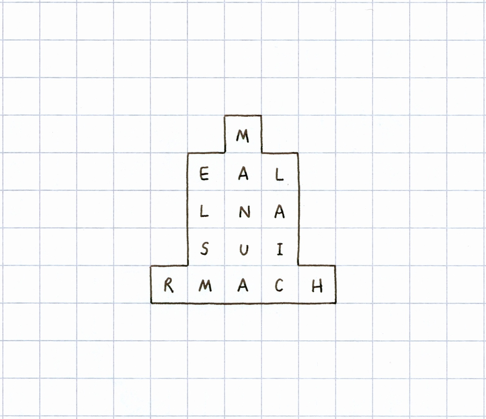
An Dùn Beag conspectus


This conspectus is composed from the names of some of the mountains that
are
visible from this location. The centre-point marks the location of An Dùn Beag.
The typography represents the view as it is experienced by the human eye, giving
an approximate impression of distance and scale. Mountain ridges are indicated
by overlapping names. The gradation of hill slopes is suggested by the use of grey-
The typography represents the view as it is experienced by the human eye, giving
an approximate impression of distance and scale. Mountain ridges are indicated
by overlapping names. The gradation of hill slopes is suggested by the use of grey-
scale, with the peak in black.
Click on this graphic to view the original and, if you wish,
print it out for use in
situ. A booklet containing all 14 conspectuses is available from ATLAS Arts. The
14 conspectuses have also been archived in an
album, indexed here. A complete
list of the mountains referred to in the An Dùn Beag guide is given below, with links
from each one to its OS map. English translations have been given where possible.
A gallery of word-mntn drawings, including mountains visible from An Dùn Beag,
can be found on the drawing page.list of the mountains referred to in the An Dùn Beag guide is given below, with links
from each one to its OS map. English translations have been given where possible.
A gallery of word-mntn drawings, including mountains visible from An Dùn Beag,
| An Stòrr | The Big (One) |
| An Teallach | The Forge |
| Beinn Edra | The Mountain Between |
| Beinn Eighe | File Mountain |
| Beinn Alligin | Bejewelled Mountain? |
| Dùn Caan | Porpoise Fort |
| Fionn Bheinn | White Hill |
| Liathach | The Hoary Place |
| Meall Dearg | Red Mount |
| Meall na Suiramach | ? |
| Mullach an Rathain | The Summit of the Pulley |
| Quiraing | Round Fold |
| Ruadh Stac Mor | Great Reddish Precipice |
| Slioch | The Spear-like Place, or Gullied Hill |
| Spidean Coire nan Clach | Pinnacle of the Corry of Stones |
| Spidean a' Choire Lèith | Pinnacle of the Grey Corry |
contributors
Alec Finlay (AF)
with
Luke Allan (LA)
Maoilios Caimbeul
Gavin Morrison
Emma Nicolson (EN)
Jessica Ramm (KR)
Gaelic consultant
Maoilios Caimbeul

No comments:
Post a Comment
Get in touch...